
December 31, 2015
Communicating Science Means Saving Lives
Posted by cbunge
Today’s post is part of a series written by student bloggers from the AGU Fall Meeting.
By: Emmanuel “Soli” Garcia, University of California San Diego
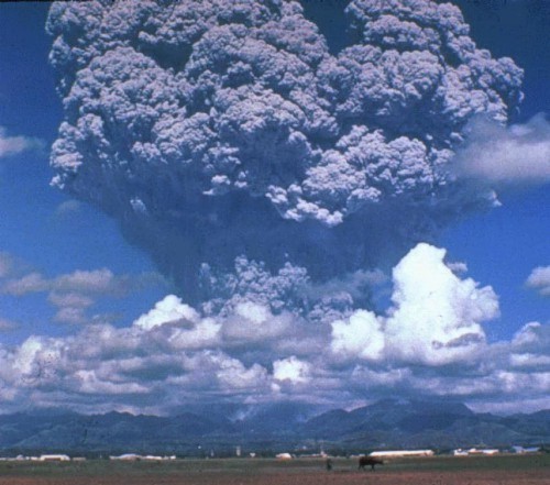
Mt. Pinatubo Ash Plume in June, 1991 Source: USGS
My recollection of the Mt. Pinatubo eruption in 1991 is dim in quite a literal sense. I may not recall much from my early childhood, but I still have memories of how ash fell on my neighborhood in Manila just under 60 miles away. As dark as the eruption’s aftermath was, the ensuing disaster could have been worse if not for the efforts of an international team of volcanologists who issued timely evacuation warnings in the vicinity of the volcano, saving numerous lives. So you could say my personal background colored my take on the talks at the Public Affairs session at the AGU 2015 Fall Meeting called “Volcanic Hazards: Translating Research and Monitoring into Improved Communication, Preparedness, and Response”.
The impact of an eruption is determined by several factors. To a geophysicist like myself, it is easy to immediately think about it in terms of the physical characteristics of the eruption, such as whether it is effusive or explosive, and whether phenomena such as lava flows, lahars, and ash plumes are likely to occur. Meanwhile, from the perspective of disaster managers and first responders, the geographic location of the volcano and its proximity to inhabited areas would be the main concern. The existence of early warning systems and the resilience of the built infrastructure in the vicinity of the volcano would also play a role in determining the ultimate effect that an eruption would have on the population.
At several times during the session, speakers emphasized the importance of disaster preparedness. A common paradigm in disaster management is to distill researchers’ cutting-edge understanding of geophysical phenomena into map form. These hazard maps are meant to illustrate the dangers posed to nearby communities likely to be affected in the event of an eruption. However, as a scientist from the USGS Cascades Volcanoes Observatory stressed, “You can’t just expect to throw a hazard map and other literature over the fence and say, ‘Here you go – you’re all set!’.” Researchers must further engage these communities at risk through other forms of public outreach. These range from preparing a media guidebook on volcano-related geoscience terms, to running field camps for young students like the GeoGirls program.
Then, there is also the possibility of involving these local communities in the production of the hazard maps themselves. In one such attempt led by SUNY Buffalo researchers, inhabitants of villages around Santa Ana (Ilamatepec) Volcano were first consulted on how a past eruption in 2005 affected their area. The researchers were at first alarmed to hear that some places had experienced what the locals referred to as a lava flow. Further field investigations revealed that what the eruption had triggered rather was a hot lahar, upon the release of impounded water. Despite wanting to insist that “No, it’s lahar, not lava,” the researchers realized instead that the locals intuitively understood the danger that flow-like events associated with eruptions posed to lives and property, regardless of the source material. They then ensured that the final hazard maps contained multiple mentions of the terms for danger and risk, apart from technical terms like lahar, mudflows, volcaniclasts, and ash.
Eyjafjallajökull Volcano Ash Cloud in Iceland, 2010 Source: NASA
The effects of ash plumes can be more widespread than the hazards I’ve already mentioned. The spread of ash from the Eyjafjallajökull eruption in Iceland last 2010 disrupted air traffic throughout Europe. Since then the UK Met Office has improved their computer models for ash dispersion. In anticipation of future events in Alaska, the USGS has also been working on developing and improving scientific tools for ash-producing eruptions. The speaker from the UK Met Office noted that they’ve been working closely with the aviation industry in delivering information that’s useful for operations. Whereas researchers plot maps of the ash cloud indicating material concentrations in the atmosphere because their models are designed to calculate them, airline managers might prefer to think of the risk to planes in terms of discrete levels of ash contamination such as low, medium and high.
Earth scientists are used to leading the way in understanding how hazards arise and develop. As this session reveals, another facet of our work should be learning how to convey our science to save lives most effectively.