
April 12, 2016
New Landslide Legislation to Help Alleviate Hazard Risks
Posted by elandau
On 3 March, 2016, the National Landslide Loss Reduction Act (H.R. 4776) was introduced by Congresswoman Suzan DelBene (D-WA-01) to establish a National Landslide Hazards Reduction Program and two competitive landslide grant programs. According to Representative DelBene; “Substantial work needs to be done to gain better knowledge of landslides and their potential impacts in order to reduce losses of life and property. While various areas across the country have been identified as hazardous, gaps in mapping remain and there is no cohesive system to share this information nationwide.”
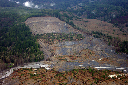
Damage from the 2014 Oso, Washington landslide. (Photo: USGS)
The national program is directed to be managed by the United States Geological Survey (USGS) and will act to identify landslide hazard risks through better assessment, coordination, and enhanced community education efforts. The two grant programs will support cooperative landslide hazard mapping and assessment practices, and also establish federal agency partnerships to fund landslide research by higher education institutions, state and local governments, and nongovernmental entities.
This legislation directs the USGS to collaborate with the National Weather Service (NWS), the National Oceanic and Atmospheric Administration (NOAA), the Federal Emergency Management Agency (FEMA), and the state geological surveys to develop guidelines and training materials for decision makers on the new landslide hazard assessment program. The bill also authorizes $8 million in support of a cooperative landslide hazard mapping and assessment program in competitive grant funds for state and local governments, and provides $10.4 million for basic landslide research through the USGS and the National Science Foundation (NSF).
Landslides impact every state and territory throughout the United States. To mitigate risks, it is imperative that we study and understand these events completely. Landslides are the least understood and identified natural hazards that occur in every American state and territory. On an annual basis, these devastating mass-wasting events are estimated to cause 25-30 deaths and up to $3 billion in damage to the United States.
In March of 2014, the city of Oso, Washington experienced a destructive and unexpected landslide which engulfed 42 homes, killed 43 people, and damaged public infrastructure. In the wake of this overwhelming event, it has become evident that the United States needs to better understand the characteristics of landslides to help alleviate future landslide-induced losses of life and property. Currently, there is no one collective landslide inventory for the United States, nor an agreed upon method of creating one. Landslide risk assessment and prediction practices are non-uniform throughout the United States, therefore creating a non-cohesive knowledge-base of these devastating natural disasters.
Multiple Federal science agencies research landslides and provide helpful products to the public, although there is an increasing need for more uniform practices and studies. Agencies such as the National Aeronautics and Space Administration (NASA) and the USGS conduct multiple types of landslide research. For example, the NASA Goddard Space Flight Center has developed a global map of potential landslide areas, which takes into account annual precipitation rates. The USGS Landslide Hazards Program creates landslide hazard maps and forecasts by studying the size, distribution, and occurrence rate of landslides, as well as the affected areas. Private sector companies such as Google have integrated ‘landslide potential’ layers into their Google Earth global imaging system. These efforts are commendable, but a collective inventory of landslide occurrences and a collaborative national assessment method is needed in order to thoroughly mitigate landslide risks.
The bill directs the USGS to establish the first national landslide hazards inventory for the United States. This collective inventory will positively impact and provide information to the research community, as well as emergency, transportation, water-quality, and public land managers, in addition to many other communities. USGS would also develop a national strategy for landslide research, as well as establish a national assessment system to identify and map landslides. This program will bring together Federal and state working-groups to establish regional priority areas for hazard assessment in a way that will help communities and potentially also save lives and property in every state of our nation.
Good content loved your page got so many information it help me so much it is so much helpful excellent page keep it up hard work pays off