January 8, 2014
The Recent Cold Snap
Posted by Erik Hankin
Over the last weekend, the temperature in the vast middle of U.S. suddenly dropped to a record low. This extreme weather is a result of a nonlinearity in the weather system, specifically a wave breaking event in the upper atmosphere. Usually the air motion in the mid-latitude is moving very rapidly within a narrow band, called the Jet Stream, which predominantly flows west to east but also contains waviness. It normally alternates between a perfect parallel pattern and various wavy patterns. Sometimes, the pattern becomes too wavy, and the ‘’tip’’ of a wave wraps up and becomes isolated, producing a wave breaking event.
The movie (Cloud Temperature Evolution – 5 January 2014) displays the evolution of cloud temperatures during the earlier stage (5 Jan.) of this extreme cold event. First the Jet Stream begins dipping southward over the continental U.S. At the same time, its “tip” slowly changes direction, signaling wave breaking. In the following 48 hours, the deepening dip in the Jet Stream indeed broke changing the Jet Stream flow to a north to south direction over the continental U.S.. This change in the large-scale dynamics allowed for the large amount of circulating cold air over the polar region (i.e. Polar Vortex) to invade far southward within the subsequent day or so!
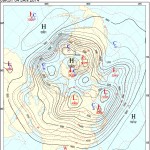
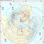
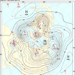
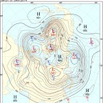
This process can also be seen from the 500hPa analysis charts (Figure 1), which show four-day successive snapshots of the atmospheric flow pattern over the Northern Hemisphere. Winds will tend to blow along the lines of constant geopotential height, i.e. parallel to the black curves. The extreme cold weather happened primarily during Sunday and Monday. From Figure 1(c)(d), we clearly see the entire polar vortex has broken out towards the continental U.S.. The very dense parallel black curves represent very strong winds, which advect cold air very easily and efficiently.

Figure 1(a). Chicago Local Time: 6:00PM, Friday, January 3, 2014. Credit: Korea Meteorological Administration

Figure 1(b). Chicago Local Time: 6:00PM, Saturday, January 4, 2014. Credit: Korea Meteorological Administration.
Figure 1(a-d): 500 hPa (approximately at 5 kilometers above ground, somewhere near the middle of the troposphere) Northern Hemisphere analysis chart. The black solid curves are geopotential heights, roughly equivalent to the trajectory of the flow. The red dashed curves are isothermals. Cold sources (polar vortex) are isolated circular isothermals, which are marked by a blue “C”. Figure from Korea Meteorological Administration.The charts also show that the key to understanding the cold spell lies in the unusual behavior of the upper atmosphere. Let’s focus on Figure 1(b); one day before the onset of extremely cold weather, the north-to-south flow was already transporting the cold air from the circular cold source region above northern Greenland and Canada (denoted by red dashed curves) to the continental U.S.. The solid black isobars were orthogonally intersecting the dashed red isotherms, meaning a strong cold advection.

Figure 1(c). Chicago Local Time: 6:00PM, Sunday, January 5, 2014. Credit: Korea Meteorological Administration

Figure 1(d). Chicago Local Time: 6:00PM, Monday, January 6, 2014. Credit: Korea Meteorological Administration.
From the above analysis, we can say with confidence that this historic cold snap was due to the irregularity of the upper atmospheric flow pattern, which lasted no longer than a few days. Let’s draw up a recipe for this event: (1) a strong polar vortex that lasts for several days provides the “fuel” of cold air; (2) a strong wave breaking event suddenly changes the atmospheric circulation and unleashes cold air from the polar vortex; (3) the polar vortex outbreak happens to be over the continental U.S..
Now, you might ask yourself: “Does the record cold mean that climate change is not real after all or perhaps that it is finished now? Alternatively, is there any connection between this cold and climate change?” We should make it clear that this is not about climate change. Climate change happens over the timescale of decades to centuries, while this event lasted only for a few days. More importantly, global warming has its roots in the physical nature of greenhouse gas, i.e. that increasing greenhouse gas should lead to a temperature rise, if no other factor is considered. The response of the Earth system to this forcing is relatively slow (much longer than this event’s duration), but quite steady.
The Earth system is a very complicated nonlinear system. If this system is perturbed, its fundamental properties, such as variability and odds of extreme events, might change. In the case of this cold snap, the nonlinearity of the upper atmosphere was the cause. Does that mean a warming world will have a higher probability of extreme events and in particular, strongly wavy flow in the upper atmosphere? This in itself is an active research field.
Such events as this have renewed our enthusiasm pertaining outstanding questions in our field. A recent communication with a colleague, Professor Pierrehumbert, highlighted a few of these questions such as “how unusual cold air extrusions from the polar vortex are and whether there has been any statistically significant change in their occurrence.” And some deeper questions like “whether CO2 can actually facilitate the build-up of near-surface cold air”.
Special thanks for discussions with: Andrew Malone, Daniel Koll, Jonah Bloch-Johnson, Dorian S. Abbot and Raymond T. Pierrehumbert.
– Lei Wang, Ph.D. Candidate, University of Chicago
Lei is a Ph.D. Candidate at the Department of Geophysical Sciences of University of Chicago studying the fluid dynamics of the atmosphere flow. In particular, Lei studies how waves can affect the mean flow, inducing the jet stream to change its location and intensity.


