June 30, 2014
Under Water: Weathering the Colorado Floods
Posted by Fushcia Hoover
By Nanci Bompey
Boulder, Colorado learned a lot about its flood management practices during last September’s historic floods. But the deluge also helped the city learn about the value of less scientific measures, like public art and a good hug, said a top public works administrator at last week’s AGU Science Policy Conference, 16-18 June, 2014.
At a panel discussion on 18 June, Jeff Arthur, Director of Public Works for Utilities in Boulder stated that with its history of flooding, Boulder had already implemented many flood management measures before heavy rains inundated Colorado’s Front Range in September 2013. “This is not a new thing and hopefully along the way we’ve learned from those past experiences,” he said.
Dedicated funding sources allowed the city to undertake master planning and mapping activities. The city’s unique open space policies helped ensure upstream watersheds were not heavily developed. Boulder’s extensive greenway system also played a role in flood management, allowing some of the city’s pedestrian and bike system to flood rather than other areas of town, Arthur said.

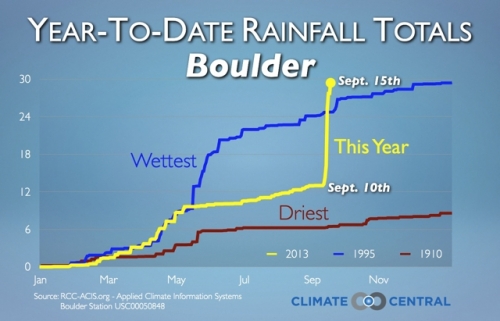
2013 total rainfall record for Boulder, CO. leading up the flood. Credit: Dennis Adams-Smith of Climate Central
Arthur additionally said that Boulder has designated areas as high hazard zones and the city has purchased homes in high hazard areas. The city also houses major scientific agencies, like the National Oceanic and Atmospheric Administration, which provides city administrators with access to large amounts of data to help plan for floods and develop warning systems. Because of these measures, areas of town that were built in accordance with local and federal standards did relatively well during the storm.
But Boulder also learned some lessons from the flood. The city was caught off guard by the large amounts of sediment and debris that traveled along with the water. Most modeling is performed using clear water and does not account for the debris, which changed the course of creeks during the flooding. Further, local governments typically don’t plan or monitor groundwater, which caused problems for the city’s sanitary system and homeowners. The city also learned that it needs to integrate future scenarios – including the effects of climate change – into plans to revitalize its downtown, explained Arthur.

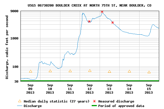
USGS discharge data for a gauge at Boulder Creek in Boulder, CO. Credit: weatherdata.USGS.gov station 06730200
“We have a lot of conversations about climate change … yet we’re looking at redeveloping the heart of our city based on really fixed lines on a map that are based on historic data,” he said. “Is there a disconnect there? Do we need to be better integrating the future and not just the past in terms of how we identify hazards?”
The floods made the city realize the value of communication and the social sciences, Arthur said. Although scientists and administrators talk about floods in terms of recurrence intervals, it’s easier for most people to understand the magnitude or impact of a flood. An art installation that put blue paint cans all over the city at the height that flood waters could reach was likely more effective than talking to residents about a ‘100-year flood’.
“There was something compelling about people standing next to a building with a lid from a paint can on it and saying, ‘Oh my god, the water would really be that deep’,” he said.
The public works department has additionally worked with the University of Colorado’s National Hazards Center to learn about how best to help residents during a disaster, including understanding the “human side of things”.
“We were dealing with a lot of people who just really needed a hug”-Jeff Arthur


