
May 17, 2018
Streamgages: Infrastructure to Protect Infrastructure
Posted by Annika Deurlington
Today’s post is written by Sandra M. Eberts, U.S. Geological Survey Hydrologist and Deputy Program Coordinator (Acting), Groundwater and Streamflow Information Program
Everyone is talking about infrastructure, especially the high cost of deferred maintenance and reconstruction. If only it were possible to keep infrastructure from degrading in the first place.
U.S. Geological Survey (USGS) streamgages can help do just that. The USGS National Streamflow Network has more than 8,200 streamgages—operated in partnership with more than 1,450 federal, regional, state, tribal and local agencies—providing real-time data on streamflow conditions. The data are critical in helping forecasters protect infrastructure by warning about rising floodwaters and guiding emergency responders in flood and hurricane recovery efforts. Engineers rely on the data for design of bridges, roads, and water-treatment plants.

A USGS field crew installs a rapid deployment gage near Myrtle Beach, South Carolina during 2016. (Public domain.)
The USGS streamgaging network is sizable, but streamgages don’t always exist everywhere they are needed during an emergency. Enter the relatively new rapid deployment gage (RDG)! RDGs are fully functional temporary gages that provide situational awareness and support to emergency managers. The USGS develops, builds, and maintains a cache of RDGs that are installed to collect and transmit near real-time data within hours to days of a recognized need. Data begin appearing on the web within minutes of installation.
Of course, improving infrastructure design and management prior to an emergency is ideal. Such proactive measures, however, can require a substantial amount of data. As an example, the USGS is investigating the effectiveness of bridge scour countermeasures for the Federal Highway Administration (FHWA). Bridge scour—erosion of a streambed around a bridge foundation caused by flooding—is the leading cause of bridge failure. The FHWA provides design and implementation guidelines for bridge-scour countermeasures. USGS scientists require information on flood histories to evaluate the effectiveness of these countermeasures and are relying upon streamgages with at least 10 years of data for this work.
How important are streamgages? Flooding is the leading cause of natural-disaster losses in the United States. More than 75 percent of declared Federal disasters are related to floods, and flood losses average almost $8 billion per year with over 90 fatalities per year.
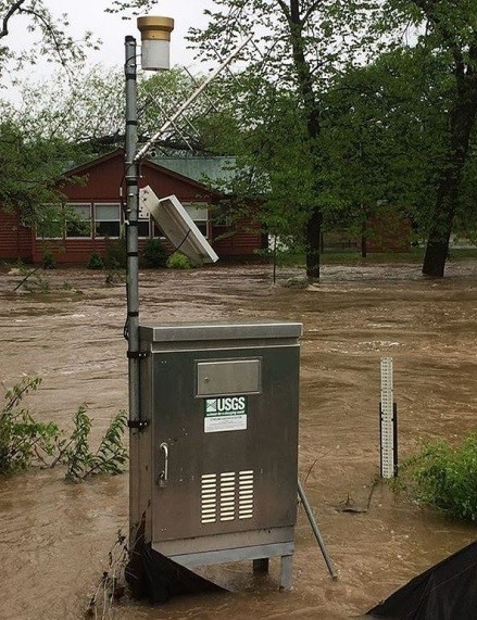
USGS streamgage on the Current River in Montauk State Park in Missouri recorded flooding during April and May of 2017. USGS crews recorded more than 20 record-high flood measurements in the Arkansas and White River basins. (Public domain.)
In April and May 2017, the demand for USGS water information exceeded 4.4 million requests per day during the flooding in Missouri, Arkansas, and Illinois. Requests exceeded almost 6.5 million per day in August and September 2017 during the flooding associated with multiple hurricanes.
Many organizations and individuals have expressed gratitude for USGS streamgaging. Coraggio Maglio, P.E., U.S. Army Corps of Engineers Galveston District (Texas), summed up his thoughts in August 2017,
“I wanted to thank your team for their stellar work yesterday moving/installing new instruments at both dams [Barker and Addicks reservoirs]. It allows us to continue to use our assets and monitoring systems of the dams in the way we intended, allowing us to do more intensive monitoring elsewhere. The professionalism and skill your team displayed should make all tax payers proud. Truly above and beyond.”
The USGS National Streamflow Network is a highly regarded “science infrastructure” that helps answer complex questions of importance to the Nation. As with any infrastructure, however, it requires investment. Many of the streamgages are in need of updating to meet new data transmitting requirements and (or) hardening to withstand major flood events. Nevertheless, infrastructure to protect lives and other [more costly] infrastructure makes sense.
I urge you to follow the Streamgages of Instagram and learn more about the wonders of USGS streamgages!
Links to USGS streamflow information:
USGS WaterWatch: discover maps, graphs, and tables of streamflow conditions.
USGS WaterAlert: subscribe for email/text notifications when water levels exceed a selected threshold.
USGS WaterNow: text a site number to [email protected] and obtain the most recent observation.
Flood Inundation Mapper: find an online library of flood inundation maps.
Streamstats: obtain estimates of flow statistics.


Thank you for the service provided on the desplaines River in Illinois. The gauge data is very helpful. Please find a way to continue the service