October 14, 2016
Crowdsourcing Geoscience: Transforming interest into data
Posted by smaguffin
As part of Earth Science Week, we’ll be highlighting different leaders in the geosciences – from research to education and community outreach. We are posting Q&A’s on The Bridge asking geoscientists about the work they do.
Today’s theme is Geologic Map Day and one of our featured AGU members is Sudhir Raj Shrestha. Sudhir works at Esri as a Solution Engineer. He has a MS in both Physical Land Resource and Soil Erosion Modeling from Ghent University, Belgium and in Soil Science and Heuristic Soil Modeling from the University of Wyoming. Sudhir is a scientific data enthusiast with a keen interest in making geospatial data easily discoverable, accessible, interoperable, and sharable. His interest and expertise fall in development and implementation of new and innovative geospatial methods and techniques. These include soil moisture, hydrological modeling, and other spatial and statistical modeling techniques that cover weather and climate forecasting and modeling. As a Solution Engineer and earth scientist, Sudhir strives to make geospatial earth science data easy to use with added value to large users with emphasis on the science community.
How important is citizen science to your work?
Citizen science is an integral part of my work as all of the federal agencies that I support put a big emphasis on citizen science. The involvement of the public in collecting and/or analyzing data for scientific purposes and projects is growing with the introduction of various novel applications that encourages collaboration. With the introduction of Web GIS, we have come so far on how we collect, analyze, visualize, collaborate, and share our information. Data contributed by citizens can be an important and valuable resource to inform scientific study, disaster response, and much more. There are many applications built to feed the data and information to and from the public and users, and one of the important aspects in weather and earth science is how crowdsourcing helps fill the data gaps in time and space.
Esri offers several applications to support citizens doing science
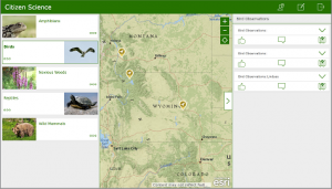
 Citizen Science Reporter: This app allows members of the public to report sightings of plants and animals. The app has been optimized for smartphones but is responsively designed to be used on smartphones, tablets, and desktop computers. The Citizen Science Reporter app presents one or more maps that can be used to report an observation. Users can anonymously submit new reports, review existing reports, comment and vote on reports or observations submitted by other users, and track the status of problems or observations they have reported.
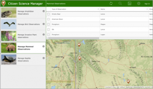
Citizen Science Manager: This is a companion app to  Citizen Science Reporter that allows users within an organization to review reports or observations submitted through the Citizen Science Reporter app. This app can be used on tablets and desktop computers.
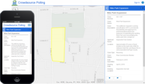
Crowdsource Polling: This app allows users to  submit comments or feedback on existing plans and proposals. The application is responsively designed to be used on tablets and desktop computers.
Crowdsource Story Map: The Story Map Crowdsource app lets you publish and manage a crowd-sourced story to which anyone can contribute photos with captions. You can use it to engage a specific or general audience on the subject of your choice.
GeoForm: This is a configurable app for form based data editing of a feature service. This app allows users to enter data through a form instead of a map’s pop-up while leveraging the power of the web map and editable feature services. This app geo-enables data and workflows by lowering the barrier of entry for completing simple tasks.
AppStudio for Quick Report: The Quick Report template can be used to create a native citizen engagement app that allows users to capture an observation and submit it to an online service.
Survey123 for ArcGIS: It is a simple and intuitive form-centric data gathering solution that makes creating, sharing, and analyzing surveys possible in just three easy steps:
- Ask questions
- Get the answers
- Make the best decisions

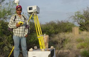
River channel mapping using ground based LiDAR (ILRIS 3D) in Walnut Gulch Research Watershed, Arizona (Collaboration project with US Army Corps of Engineers, USDA- ARS and NASA Goddard)
There is a wealth of information about geospatial science and how Esri technology can be instrumental in supporting your research in earth science. We conducted online live training seminar on “Using Multidimensional Scientific Data with ArcGIS” that are recorded. The goals of this seminar is help you construct a mosaic dataset for multivariate, multidimensional rasters; derive information products from multidimensional mosaic datasets; publish and share multidimensional image service and visualize dynamic services in the ArcGIS online map viewer. You can access it here.
How are maps and earth science data transforming the world?
With an ever increasing wealth of earth science data produced from various sources and platforms including earth observation and modeling, the opportunities to exploit such vast amounts of data and products are challenging and exciting. These data are widely used for monitoring, simulation, and analyzing measurements that are associated with physical, chemical, and biological phenomena over the ocean, atmosphere, or land. The volume, variety, and complexity of multidimensional earth science data pose challenges with how it is shared with a diverse community, visualized intuitively, or fused for answering scientific questions. Government agencies like NOAA, NASA, EPA, and USGS produce large volumes of near real-time, forecast, and historical data that drives climatological and meteorological studies, and underpins operations ranging from weather prediction to sea ice loss. Modern science is computationally intensive because of the availability of this enormous amount of scientific data, the adoption of data-driven analysis, and the need to share data and research results with the public. Improved commercial off-the-shelf (COTS) software solutions and mapping technology have made a tremendous impact on how we ingest, manage, analyze, visualize, and share the complex scientific data that can be consumed by scientists, policy makers, and the general public.
If you want to know more about Scientific Data and how Esri technology can used to support your scientific data, then you can take a look at our presentation on “Using ArcGIS as a Scientific Data Platform”.
Science Portal gives you an access to earth observation and other geospatial data.
GeoNet (The Esri Community) gives you an opportunity to interact and contribute your work to larger geospatial science community.
You can follow more of Sudhir’s work as well as Esri on twitter @Sud_Shrestha (Personal), @esriscience (Esri Science Team), and @esri (Esri).

